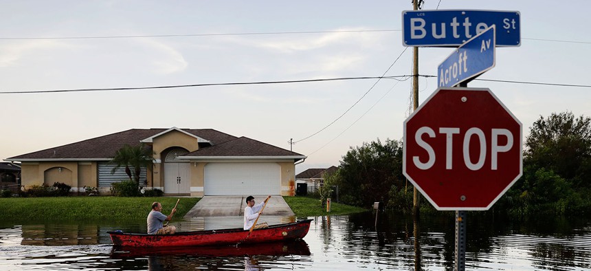
Pierre Ghantos, left, and his son Nathan paddle though their flooded neighborhood in the aftermath of Hurricane Irma in Fort Myers on Tuesday. David Goldman/AP
How the National Weather Service Prepares for the Worst
The agency’s new philosophy gives it a much more active role in girding for disasters.

COLLEGE PARK, Md.—“I woke up Friday night with a dream that it had missed the peninsula,” said Bill Lapenta, the director of the National Centers for Environmental Prediction.
We sat looking at a screen that showed Hurricane Irma’s long journey across the Atlantic Ocean. Another monitor showed a live satellite feed of the cyclone, the hurricane a splotch of rainbow data, its eye coming closer and closer to the Florida mainland. Across the room, Jim Cantore shouted through the television that Irma was about to make landfall.
Lapenta had been thinking about Hurricane Irma for days. No element of the storm’s forecast, he told me Sunday, was more important than its projected last-minute turn in the Florida Strait. For more than a week, meteorologists had insisted that the storm would travel west along the Cuban shore before suddenly shifting north toward the Florida peninsula. If it failed to pivot, it would sail harmlessly into the Gulf of Mexico. Six million people had been evacuated on the basis of this alleged turn. Florida had declared a state of emergency, and the governor called up the national guard.
It was as assured as anything ever is in hurricane prediction—but it was not certain. If the turn materialized, it would do so less than a day before landfall. So Lapenta, who oversees the National Hurricane Center as well as eight other environmental offices within the National Weather Service, dreamt a nightmare of a turn-less Irma. He checked the official forecast again on his phone.
“It probably would’ve been good for the public impacts, though somewhere in the panhandle might have gotten slammed,” he told me, of his dream. “But for us ... it would have been a huge miss.”
It wasn’t a miss. On Saturday evening, Irma verified the NWS’s forecast, gliding north through the Florida Strait and tearing into the state’s southwest. It hit a state that—at least from the weather service’s perspective—was as well prepared as it could be for the storm.
For the National Weather Service, Irma’s landfall represented an important validation not just of its new long-term hurricane-prediction tools, but of its entire shift of strategy four years ago. Instead of issuing forecasts and warnings, the agency now considers part of its job to be helping local and state governments prepare for incoming disasters
“History is being made today, I have no doubt,” said Louis Uccellini, the director of the National Weather Service, in an exclusive interview on Sunday. He told me that new technology—including new satellites and modeling tools—as well as a revamped institutional philosophy amounted to a complete change in how the agency prepares for hurricanes.
The agency’s leadership was eager to show off that philosophy on Sunday, as its forecasters rushed to describe and predict the storm’s finale. They call their new strategy “Weather-Ready Nation,” and it emerged as an idea from a few of the most traumatic days in American weather history.
On April 3 and 4, 1974, while Uccellini was still studying meteorology at the University of Wisconsin, an extraordinary outbreak of tornadoes struck the American Midwest. More than 140 tornadoes rolled across 13 different states on those two days, causing the equivalent of $3.9 billion in damage in today’s dollars. More than a dozen tornadoes might have spun across the plains simultaneously.
At the time, the Weather Service saw its role as rather limited. “Watches and warnings worked completely differently than they do now,” said Uccellini. Local offices published forecasts every morning and strayed little from their designated role. The service issued a tornado watch only after a whirlwind had touched down.
Across the two-day “super outbreak,” more than 315 people died.
It was the largest rash of tornadoes ever recorded—until the super outbreak of April 2011. On April 27 and 28, 2011, 362 tornadoes touched down across the central and southeastern United States. Four of them were rare EF5s, enough to tear houses from their foundations and level entire towns.
This time, the National Weather Service was ready. It issued a nationwide “convective outlook” the morning of April 27, giving the day its highest-ever tornado-danger level for the first time ever. Ninety-five percent of its tornado watches preceded an actual tornado. Tornado warnings—alerting residents to an imminent twister—were issued, on average, 24 minutes before a tornado swept through an area.
It was a remarkably accurate set of forecasts. It represented the triumph of a long series of changes—like installing nationwide Doppler radar and requiring all NWS employees to have bachelor’s degrees—that the service implemented during the 1990s and 2000s.
“And yet the same number of people died,” said Uccellini. For all the agency’s forewarning, the super outbreak of 2011 killed more than 320 people. Earlier warnings, more precise forecasts, and faster communication tools did not keep the contemporary outbreak from killing more people than its 1974 predecessor. What happened?
Agency leadership fell into a series of meetings with politicians, emergency planners, and social scientists to figure it out. “The expression in that meeting was ‘You’ve got to go the last mile with your forecasts,’” Uccellini said. “We needed—with a sense of urgency—to move beyond forecast warnings and connect with decision makers.”
After months of meetings (which Uccellini led), the agency settled on a new guiding philosophy in late 2011: “Building a Weather-Ready Nation.” Instead of merely publicizing changes to the weather and hoping people noticed, it would take responsibility for getting sound science to officials. It embraced resilience and responsiveness as worthwhile goals, and it recruited “Weather-Ready Ambassadors” to communicate the dangers of impending natural disasters. (One of the ambassadors is Nextdoor, a social-networking app for neighborhoods that was used by Hurricane Harvey rescuers. Another is The Weather Channel.)
The National Weather Service now regularly lends its meteorologists to other government agencies in advance of a major disaster. NWS meteorologists rode out Hurricane Irma at the offices of the Department of Homeland Security and the Federal Emergency-Management Agency. Florida’s state government and numerous counties also asked for—and received—an agency meteorologist to watch the storm with them.
“We don’t invite ourselves in; we get invited in. We interact through email and social media generally. And then, last weekend, when we were talking about this storm taking a hard right turn into Florida, we started embedding and connecting on a much more urgent basis,” Uccellini told me.
In the eyes of agency leadership, this early planning allowed Florida to declare a state of emergency almost a week before Irma’s landfall. The state could then begin to evacuate its population, which is a mosaic of vulnerable groups: Florida has more tourists, more older people, more non-English speakers, and more people living near the coast than most other parts of the United States.
The 2011 super outbreak of tornadoes also changed how the National Weather Service talks about the weather. It no longer says just that there is a risk of a dangerous tornado; now, it deploys specific and evocative language: “A tornado is forming here, and it will be strong enough to flatten a house,” for instance. That focus on clear language and easy-to-understand instructions helped the service’s Key West forecast office warn locals as Irma loomed:
***EVERYONE IN THE FLORIDA KEYS***
— NWS Key West (@NWSKeyWest) September 10, 2017
***IT IS TIME TO HUNKER DOWN***
***THE WORST WINDS ARE YET TO COME***#Irma #FLkeys #flwx pic.twitter.com/lmHTcRv68l
Many of these new informal relationships between the National Weather Service and state and local governments were codified in the Weather Research and Forecasting Innovation Act, which President Trump signed in April.
A new philosophy was not the only first for the weather service. Irma brought unusual prominence to the NOAA Center for Weather and Climate Prediction, a four-story building near the University of Maryland that looks like a ship’s sail stiffened with wind. The structure is home to four of the agency’s nine environmental-prediction centers, including the teams that forecast ocean weather, develop new weather models, and advise local forecasters nationwide.
Since last week, it also houses an altogether more informal office.
Normally, the National Hurricane Center, or the NHC, operates out of a glorified bunker in Miami—its hardened steel headquarters can withstand Category 5 winds and more than a dozen feet of storm surge. But with early forecasts asserting that Irma would batter the city, the weather service prepared for the possibility that the hurricane center could be cut off from the world. So the agency relocated two Miami-based forecasters, as well as meteorologists from Kansas and Hawaii, to College Park.
They took up residence in a cubicle pod in the middle of the floor. “Quiet please: NHC NORTH,” read a whiteboard next to their makeshift office.
Twelve screens showed loops of Irma, data readouts, the results of model runs. Around those were arrayed the accoutrements of an office that had been working, nonstop, for days. A giant bottle of chewable vitamin C sat by one screen; cardboard palettes of Cup Noodles were stacked by the printer. A central table had clementines, hand sanitizer, an empty bear-shaped jar of animal crackers, and a well-raided box of Maryland’s great delicacy, Berger’s cookies.
“Every year we practice backing up the NHC and hope we never have to do it,” said Kathryn Gilbert, the deputy director of the agency’s Weather Prediction Center. Irma gave them no choice. To help the deluged agency, “NHC North” took over some of the minor storms so the Miami team could focus entirely on Irma. While they were at it, the Maryland forecasters also ran backup on Irma.
For the forecasters pulled together to staff NHC North, the improvised office was like a family reunion. Greg Carbin, normally the chief forecaster for the Weather Prediction Center, wrote a forecast discussion—a public memo describing Irma’s track and strength—one evening. (Fellow professional-meteorologist friends texted him to ask why.) Another meteorologist, who flew in from Honolulu and specializes in Pacific storms, produced the official forecast for Hurricane Jose. (For the next few days at least, it would do a loop-de-loop in the Atlantic high seas, he said.) Another group of three forecasters mirrored the official Irma forecast, so they could take over if the Miami office suddenly went down.
Lapenta described watching the data come in on Saturday night. Despite spending 30 years as a weather modeler at NASA, he still marveled at the accuracy of the forecast. “I’m sitting there watching, and it’s like, when’s it gonna turn? When’s it gonna turn? And then late last night, it came to a stop, and I watched it start drifting north,” he said. He gestured to the screen showing Irma’s track. “How did they know that?” he said. “How did these things do it?”
The atmosphere at the National Weather Service on Sunday was collegial, serious—and just a tiny bit thrilling. Many of the technologies used to predict Irma only became operational in the last few years, but it’s the logistics of getting these ever-more-accurate forecasts to the people that the NWS says make the biggest difference.
“Ten years ago, I don’t think in any way shape or form that [we could have predicted] that this would come up, stop on a dime, and move up the coast,” Lapenta said. But “all this technology doesn’t mean anything if you can’t convey it to people who need to make decisions.”
NEXT STORY: Working Alone ‘Together’ Can Be Good Motivation